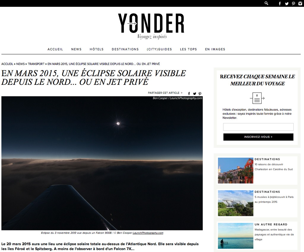
Total Solar Eclipse of 2015 March 20
from the stratosphere aboard a Dassault Falcon 7X business jet
Design by T. Nordgren
The point of greatest eclipse (totality phase during 2 min 46 sec) was located in the middle of the North Atlantic Ocean east of Iceland and northwest of the Faroe Islands. As weather prospects weren’t that great for the few ground-based locations, seeing it from the stratosphere was tantalizing. Svalbard was the second choice as there are quite a few clear days at that time of the year, and the fact is the sky was indeed clear on eclipse day. The Faroe Islands were the third choice as the weather there changes very quickly which is why some saw it and others didn’t.
Firstly I would like to thank all the players (Amjet Executive and Dassault and their employees as well as the private owners who have provided their aircraft) who participated in one way or another to this wonderful adventure which required two years of preparation. Despite many difficulties we finally managed to achieve these demanding flights which will without doubt be remembered for a long time. Lets look forward to the next opportunity and do not hesitate to solicit me! And of course thank you to all the participants for your trust.
The planning of these flights was a response to a real need and had from the beginning a scientific justification with the opportunity to study the solar corona at wavelengths outside of the visible spectrum. It is a good example of cooperation between amateurs and professionals. To be nearly assured to view this eclipse with a clear sky, quite a few eclipse flights were organized near the Faroe Islands and inside the umbral shadow path there were:
four Dassault Falcon 7X business jets, for which I coordinated the flight paths, all flying high over the pack at altitudes up to 49,000 feet (14,935 meters) into the lower stratosphere,
11 specially chartered aircrafts (from FL340 to FL400). Those were regular commercial aircrafts such as A320-200, B737-800, B757-200 and MD-83,
and about 12 regular commercial flights (some of them altered their course and others even did loops to please their passengers, crew and pilots).
There was also a CASA CN-235 from the Irish Air Corps flying down the path near Ireland, for which I provided the flight path. Further away from the Faroe Islands, one Dornier 228 flew over Longyearbyen, Svalbard, and another flight out of Murmansk, Russia, made an intercept in between.
Among the four Falcon 7X business jets, two were out of Paris-Le Bourget, one out of Geneva and the last one fully privatized out of Antwerp. The first three, a total of 50 people, flew at altitudes between 49,000 feet (14,935 meters) and 47,000 feet (14,326 meters) and the last one at 43,000 feet (13,106 meters). All the eclipse flights were highly successful. After the eclipse the first three Falcon 7X made a stop-over in Vágar, Faroe Islands, before returning to their respective take-off airports, while the fourth went back directly to its home port. The first Falcon 7X, the one I was aboard, was carrying scientific experiments for the Institute for Astronomy at the University of Hawaii and the second aircraft had one as well for the Paris Institute of Astrophysics.
My Solar Eclipse Maestro software was used to prepare the flights and also in-flight to make adjustments. The deviations in distance, heading and altitude from the planned intercept course were constantly updated so that adjustements could be made anytime when required.
About a week before the eclipse and just after my return from Indonesia to scout locations and prepare for the 2016 March 9 total solar eclipse, Isavia, the Icelandic Air Traffic Control entity in charge notably of the airspace to the northwest of the Faroe Islands, issued a directive restricting eclipse flight operations only along two specific tracks designated "Solar Eclipse East" and "Solar Eclipse West". The names reflect Isavia’s intention to develop two specific corridors on either side of centerline, roughly but not exactly parallel to it as Isavia staff used integer values for the entry and exit coordinates. It is worth noting that this directive doesn’t apply to all the flights, it all depends on the status under which a flight is registered. Although the position of those two tracks were suboptimal particularly at flight levels over 450, and after numerous exchanges with the air traffic control in Iceland, we finally decided to use them for three of the four Falcon 7X, the fourth having its own optimal track. As we will see later this decision had dire consequences on the true heading of the aircrafts, i.e. the direction the nose is pointing.
Moreover the predicted no-wind duration(s) of totality were thus slightly lowered by about one second. With actual winds aloft we got a duration of about 3 minutes and 46 seconds as predicted when taking into account the wind vectors.
Leader Flight Analysis
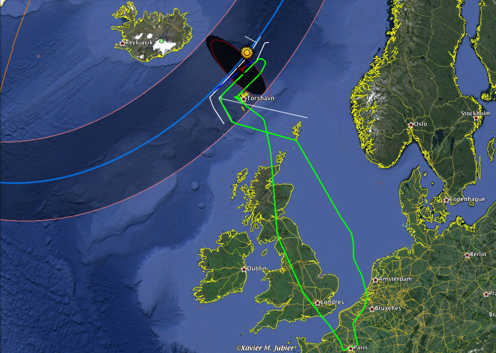
The map below shows in white the two "Isavia" tracks with their respective inbound and outbound routes. The nominal totality run trajectory is displayed in navy blue and red for the totality part, while the execution of the Falcon 7X leader flight is in green. The nominal trajectory is there to provide both the longest totality duration and more importantly to have the passenger cabin of the aircraft perpendicular to the eclipsed Sun. The shaded totality path and centerline are displayed at sea level, and the umbral shadow is drawn at sea level but also as a red outline at FL485.
This map shows the whole Falcon 7X leader flight from take-off at Paris-Le Bourget business airport to the eclipse intercept followed by its landing in Vágar and later on in the afternoon its return to Paris-Le Bourget.
The animation below show the execution of the stratospheric Falcon 7X leader flight, in green, compared to the nominal trajectory, in navy blue. The shaded totality path is drawn at sea level, the dotted lines, red for the northern and southern limits, orange for the centerline, at flight level 485 (a.k.a. FL485). The umbral shadow during the totality intercept is drawn at both sea level and FL485.
As it can be seen there is a variable deviation of about 10 nautical miles from the nominal trajectory. Unfortunately Isavia didn’t leave much room to make beneficial improvements.
Simulation of the stratospheric eclipse observation flight over the North Atlantic Ocean.
Nominal trajectory in navy blue, flight track in green. The yellow arrow, when displayed, indicates the direction of the Sun.
The animation below show the execution of the stratospheric Falcon 7X leader flight, in green, compared to the suboptimal "Isavia Solar Eclipse East" track, in navy blue.
A few important observations can be made. First there is a delay of 10 seconds from the optimal trajectory, this wasn’t an issue for the quality of the eclipse observations. On the other hand the issue concerning the angle of the aircraft’s passenger cabin with the eclipsed Sun is serious: the value to watch for is "LoS". During totality you can notice that the angle value goes from 6 to 7 degrees, which means that the windows of the aircraft were not perpendicular to the eclipsed Sun and thus the path of the light rays was far from optimal to avoid or at least reduce aberrations. An acceptable value would be between 0 and 2 degrees. Unfortunately with the strong crosswinds it was physically impossible to reach this value range while remaining on the suboptimal trajectory imposed by Isavia.
Execution of the stratospheric eclipse observation flight over the North Atlantic Ocean.
Subnominal trajectory imposed by Isavia in navy blue, flight track in green. The yellow arrow, when displayed, indicates the direction of the Sun.
Falcon 7Xs Inflight Reunion
After takeoff the four Falcon 7Xs were to rendezvous while approaching the Faroe Islands on their way to their respective interception trajectories.
Approach course for the Falcon 7Xs
Second Falcon 7X, coming from Paris-Le Bourget, flying below the first
The Moon’s umbral shadow is now racing us at high speed and the unique light before totality gives us chills. The shadows created by the clouds become sharper as the thin sliver of the Sun is reduced.
The light changes shortly before the arrival of the Moon’s umbral shadow followed by totality
Leader Flight Progress
The aircraft is now stabilized at a true airspeed of 469 knots (Mach 0.81) on the totality trajectory at flight level FL485, i.e. 48,500 feet (14,790 meters). The pitch angle is 2.5 degrees and the crosswinds aloft are strong (43 knots from 316 degrees). Mid-totality is now approaching.
Flying into the stratosphere with a Dassault Falcon 7X business jet at FL485, that is 48,500 feet (14,800 meters) inside the umbral shadow cone
We’re now at mid-totality and the elliptical shape of the umbral shadow over the cloud tops is obvious. The eclipsed Sun is nearly opposite to the view. On the white shirt of the chief pilot we can imagine the typical and magic color of the light of the solar corona.
Flying into the stratosphere with a Dassault Falcon 7X business jet at FL485, that is 48,500 feet (14,800 meters) inside the umbral shadow cone
The umbral shadow of the Moon is now approaching fast at nearly 3,200 kph (2,000 mph), and starts to catch up the aircraft coming from our back with a speed differential of more than 2,000 kph (1,250 mph). And here we go for nearly four minutes of totality, over one minute more than for a stationary observer, before the umbral shadow completely overtakes the aircraft. With the help of the reflections on the cockpit windows, one can see the main console and the sunset opposite the eclipse.
Flying inside the Moon’s umbral shadow cone during 3 minutes and 46 seconds at 48,500 feet (14,800 meters)
[Venus can be seen on the left of the eclipsed Sun]
Because of a DSLR camera malfunction, likely a bad coupling between the body and the telephoto lens, very few images are available. Fatigue, excitement and various concerns certainly also contributed to the problem.
Solar corona
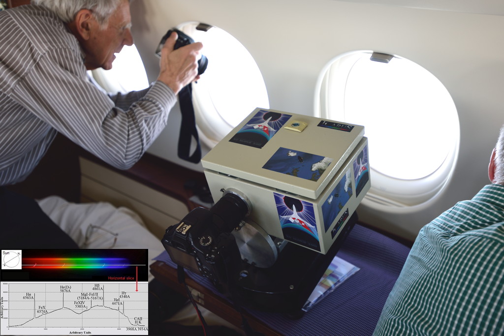
During the intercept and because we had scientific experiments onboard, we flew with no navigation lights and the anti-collision beacon light turned off during about fifteen minutes. Computer controlled and gyro-stabilized custom-made platforms were installed inside the aircraft’s passenger cabin. Two of those instruments studied the solar corona in the near infrared, a feat that is very difficult from the ground because the Earth atmosphere filters those wavelengths. By flying at very high altitude we can almost completely overcome this problem.
The many operational constraints did not facilitate our work, but this flight will remain as a great success that helped improve the knowledge of our Sun. The exploitation of the data collected will take a number of months before the results are published.
Some of the scientific equipment from the Institute for Astronomy of the University of Hawaii installed aboard the Falcon 7X leader aircraft
(the other teams composing the "2015 Solar Wind Sherpas" were located in Svalbard, the Faroe Islands and off Ireland)
Setup of one of the scientific plateforms in the near infrared
Slitless spectrograph of the Aristotle University of Thessaloniki
The yellow cross northwest Faroe Islands indicates the position of the Falcon 7X at 9:45 UTC during totality. One can observe the rapid movement of the umbral shadow; nevertheless the size of the shadow is greatly exaggerated in the animation due to the digital image processing. However, the movement of cloud masses is clearly visible and perfectly explains the observed winds aloft.
Animation of the satellite imagery on 2015 March 20 from 7:30 to 11:30 UTC
Thanks to our co-pilot for sharing this video showing the Moon’s umbral shadow race over the clouds at nearly 3,200 kph (2,000 mph).
Fast-forward (8x) of the Moon’s umbral shadow race from 48,500 feet (14,800 meters)
About an hour after a successful rendez-vous with the eclipse, the Falcon 7X coming from Geneva-Cointrin is preparing to land at 11:40am in Vágar, Faroe Islands, where the weather is difficult with a strong crosswind of nearly 40 knots (thanks to Guillaume Hébrard, who was on the ground nearby the airport and did manage to see totality, for both pictures). On the third photo one can see the three stratospheric Falcon 7X parked in Vágar. We flew back at around 2pm.
And now from the Paris-Le Bourget business airport, in front of the Falcon 7X #2, a good part of the Dassault Falcon Service staff (crew and ground) who actively participated to this wonderful adventure. Again thank you all!
This map shows most of the different flights that could view the 2015 March 20th total solar eclipse. However two of the four Falcon 7X, including the one I was aboard, are not displayed. One can also notice that one of the displayed Falcon 7X is not flying onto the two "Isavia" solar eclipse tracks, this is normal as explained earlier.
About twelve regular commercial flights, some of them altered their course and others even did loops to please their passengers, crew and pilots, had the chance to briefly view the solar eclipse.
Regular flights and chartered aircrafts which could view the 2015 total solar eclipse
Below you can see the subdivisions of the European airspace and the various air routes in the area of the eclipse controlled by Isavia.
Finally here is how one can observe a solar eclipse with distinction from the Falcon 7X #3:
Guillaume Cannat who notably runs the blog "Around the Sky" of Le Monde, a well-known French newspaper, was on board the Falcon 7X out of Geneva. He recounts his adventure through two posts dated 21 March and 23 March.
Kringvarp Føroya46-minute documentary aired on 2015 May 7th at 9:25pm
(the sequence featuring my group starts at the 29:00 timecode and lasts six minutes)
Visitors
A total solar eclipse creates a broad international interest as shown by the instantaneous visitors on my website at midnight on March 19th.
Instantaneous visitors on my website at midnight on March 19th
Flight Planning and Feasibility
With the help of Dassault Aviation, different flight plans were studied in order to assert the feasibility of the whole operation at very high altitude.
Early flight plan to intercept the umbral shadow cone from Paris-Le Bourget to Vágar