|
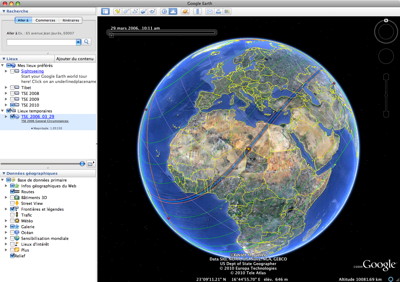
The Google Earth (available for MacOS X, Windows and Linux) files, will draw the solar eclipses paths and limits across the Earth’s surface (using 5MCSE Besselian elements from Fred Espenak and Jean Meeus, NASA/GSFC). The umbral or antumbral northern and southern limits of a solar eclipse are plotted in pink while the central line is blue. After having been nine years online, the content of those files has been updated mid-2013 and synchronized with the one produced by my "Five Millennium Canon of Solar Eclipses" tool.
The "dynamic local circumstances predictions at the click’s location", a feature available with my interactive Google maps, can’t be implemented as is because the Google Earth client application provides no means of getting the current pointer position. However, by clicking on the framed cross-hair cursor  always located at the center of the view, you will obtain the local circumstances at that location (have a look at this sample). The Five Millennium Canon of Solar Eclipses Database will give you access to every eclipses over the -1999 to +3000 period and will let you generate those files on your own. always located at the center of the view, you will obtain the local circumstances at that location (have a look at this sample). The Five Millennium Canon of Solar Eclipses Database will give you access to every eclipses over the -1999 to +3000 period and will let you generate those files on your own.
When a link is followed by this symbol  , it means you have two different files. The first one is a plain Google Earth file; the symbol, being the second one, is a self-contained Google Earth file with new high resolution satellite image overlays. These images include material copyrighted by Space Imaging LLC. Permission to distribute, sell, license, copy or reproduce these files isn’t granted. Alter or remove any copyright notice or proprietary legend contained in is forbidden. Instead, please provide this Web page address to anyone wishing to use the Google Earth files and ask me if you have any special needs. , it means you have two different files. The first one is a plain Google Earth file; the symbol, being the second one, is a self-contained Google Earth file with new high resolution satellite image overlays. These images include material copyrighted by Space Imaging LLC. Permission to distribute, sell, license, copy or reproduce these files isn’t granted. Alter or remove any copyright notice or proprietary legend contained in is forbidden. Instead, please provide this Web page address to anyone wishing to use the Google Earth files and ask me if you have any special needs.
You can then overlay meteorological data files with the eclipse path or have a look at the Google Earth Gallery.
Total or Hybrid Eclipses
|
Please consider making a donation to support my work and show your appreciation.
These innovative maps were the first to reach the market over a decade ago and have since constantly evolved to bring more added value to the visitors.
The Five Millennium Canon of Solar Eclipses Database will give you access to every eclipses over the -1999 to +3000 period.
Google Earth screenshot showing the track
of the March 2006 total solar eclipse.

Initial view once you have done a "File -> Open".
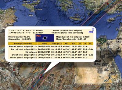
Interactive Google Map screenshot showing the track
of the March 2006 total solar eclipse.

The detailed local circumstances bubble can display data,
computed on the fly, from any click location.
Lunar limb profile and Baily’s beads screenshot.

|
|
Total on Wednesday, February 15, 1961
Total on Sunday, September 22, 1968
Total on Saturday, March 7, 1970
Total on Monday, July 10, 1972
Total on Saturday, June 30, 1973
Total on Monday, February 26, 1979
Total on Friday, March 18, 1988 in the Pacific Ocean, in the Philippines or in Indonesia
Total on Sunday, July 22, 1990 in the Chukotka Okrug, Soviet Union or in Finland
Total on Thursday, July 11, 1991 in Hawaii, USA
Total on Tuesday, June 30, 1992
Total on Thursday, November 3, 1994 in Bolivia
Total on Tuesday, October 24, 1995 in India, Pakistan or Afghanistan
Total on Sunday, March 9, 1997 in Russia
Total on Thursday, February 26, 1998 in Aruba
Total on Wednesday, August 11, 1999 near Coucy-le-Chateau, France
Total on Thursday, June 21, 2001 south of Lucusse, Angola
Total on Friday, December 4, 2002 near Andamooka, Australia
Total on Sunday, November 23, 2003 in the Dronning Maud Land, Antarctica
Hybrid on Friday, April 8, 2005 in the South Pacific Ocean
Total on Wednesday, March 29, 2006 or  in Serir Tibesti, Libya in Serir Tibesti, Libya
Total on Friday, August 1st, 2008 in China, Mongolia or Russia
Total on Wednesday, July 22, 2009 in China or on Ishinomura-Kitaio Island, Japan
Total on Sunday, July 11, 2010 on Easter Island, Chile, in French Polynesia or in Argentina
Total on Wednesday, November 14, 2012 in Australia or in the Southern Pacific Ocean
Hybrid on Sunday, November 3, 2013 airborne, in Kenya, Uganda, Ethiopia or Gabon
Total on Friday, March 20, 2015 airborne, in Svalbard, the Faroe Islands or near the North Pole
Total on Wednesday, March 9, 2016 in Indonesia or Micronesia
Total on Monday, August 21, 2017 in the United States of America
Total on Tuesday, July 2, 2019 in Chile or Argentina
Total on Monday, December 14, 2020 in Argentina or Chile :
Total on Saturday, December 4, 2021 from Union Glacier or Patriot Hills, Antarctica :
Hybrid on Thursday, April 20, 2023 in Australia or Indonesia :
Total on Monday, April 8, 2024 in Mexico or the USA :
Total on Wednesday, August 12, 2026 in Iceland or Spain
Total on Monday, August 2, 2027 in Egypt or Saudi Arabia
Total on Saturday, July 22, 2028 in Australia
Total on Monday, November 25, 2030 in Australia
Hybrid on Friday, November 14, 2031 in the Pacific Ocean
Total on Wednesday, March 30, 2033 in Alaska
Total on Monday, March 20, 2034 in Chad or Sudan
Total on Sunday, September 2, 2035 in China or Japan
Total on Monday, July 13, 2037 in Australia
Total on Sunday, December 26, 2038 in Australia or New Zealand
Total on Thursday, December 15, 2039 in Antarctica
Total on Tuesday, April 30, 2041 in Angola
Total on Sunday, April 20, 2042 in the Philippines
Total on Thursday, April 9, 2043 in Russia
Total on Tuesday, August 23, 2044 in Canada or the USA
Total on Saturday, August 12, 2045 in the USA
Total on Thursday, August 2, 2046 in Angola or Botswana
Total on Saturday, December 5, 2048 in Argentina
Hybrid on Thursday, November 25, 2049 in Sumatra (Indonesia)
Hybrid on Friday, May 20, 2050 in the South Pacific Ocean
Total on Saturday, March 30, 2052 in Mexico or the USA
Total on Friday, September 12, 2053 in Saudi Arabia or Egypt
Total on Saturday, July 24, 2055 in South Africa
Total on Friday, January 5, 2057 in the South Indian Ocean
Total on Wednesday, December 26, 2057 in Antarctica
Total on Sunday, May 11, 2059 in Ecuador or Peru
Total on Friday, April 30, 2060 in Libya
Total on Monday, January 6, 2076 in Antarctica
Total on Wednesday, May 11, 2078 in Mexico or the USA
Total on Monday, May 1st, 2079 in the USA or Canada
Total on Wednesday, September 3, 2081 in France or in the United Arab Emirates
Total on Saturday, September 23, 2090 in France
Total on Saturday, January 16, 2094 at the South Pole in Antarctica
Total on Sunday, May 11, 2097 in Alaska
Total on Monday, September 14, 2099 in the USA or Canada
|
Annular Eclipses
Annular on Wednesday, May 30, 1984 in the United States of America
Annular on Tuesday, February 16, 1999 in Australia
Annular on Friday, December 14, 2001 near Nosara, Costa Rica
Annular on Monday, June 10, 2002 in Mexico, Indonesia or the Northern Mariana Is.
Annular on Saturday, May 31, 2003 in Greenland
Annular on Monday, October 3, 2005 or  near Waw an Namus, Libya near Waw an Namus, Libya
Annular on Friday, September 22, 2006 near Kourou, French Guiana
Annular on Thursday, February 7, 2008 or  in Ellsworth Land, Antarctica in Ellsworth Land, Antarctica
Annular on Monday, January 26, 2009 in Indonesia
Annular on Friday, January 15, 2010 in Myanmar, Bangladesh, India or Kenya
Annular on Sunday, May 20, 2012 in the United States of America or Japan (21st)
Annular on Friday, May 10, 2013 in Australia, Solomon Is. or Kiribati
Annular on Tuesday, April 29, 2014 in Antarctica
Annular on Thursday, September 1st, 2016 in Madagascar, Tanzania or La Réunion
Annular on Sunday, February 26, 2017 in South America or Angola
Annular on Thursday, December 26, 2019 in Indonesia
Annular on Sunday, June 21, 2020 in Oman or India :
Annular on Thursday, June 10, 2021 in Greenland, Canada or Russia :
Annular on Saturday, October 14, 2023 in the United States of America or Mexico :
Annular on Wednesday, October 2, 2024 on Easter Island, Chile
Annular on Tuesday, February 17, 2026 in Antarctica
Annular on Saturday, February 6, 2027 in Argentina
Annular on Wednesday, January 26, 2028 in the Galapagos
Annular on Saturday, June 1st, 2030 in Siberia
|
|
 Google Earth Files (kmz)


