Annular Solar Eclipse of 2017 February 26
from Argentina & Esquel WDEA II Workshop
In the days leading the annular, from February 22 to 24 an eclipse workshop (in Spanish) will be held in Esquel, Argentina, at the Centro Cultural Esquel Melipal. Among the foreign speakers you will find Jay M. Pasachoff, Charles Fulco and myself.
Apart from the workshop this annular eclipse has a particular interest as its ring will be quite thin, which can help get nicer Baily’s beads and views of the chromosphere in a similar way as its predecessor of the Saros 140, namely the February 1999 annular in Australia.
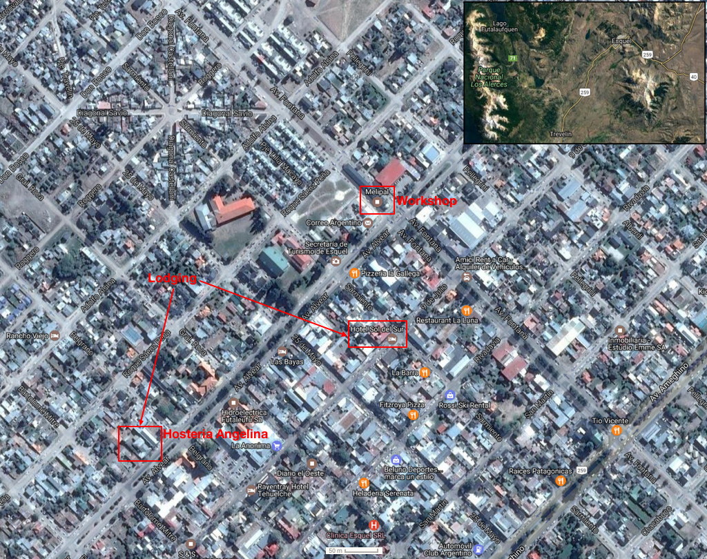
The map shows the location of the workshop, main lodging and restaurants in town.
Final program of the WDEA II workshop (with speakers):
Viewing an annular solar eclipse from the northern or southern limits can be more rewarding than from the centerline. However to maximize your experience and lengthen the duration of the Baily’s beads you need to be positionned properly. Two main options are therefore possible: the first is to get both some short annularity time with prolonged beads or else only prolonged beads by staying in the grazing zone. In both cases the chromosphere can also be viewed while not using any solar filter at the proper time (CAUTION THE LATER PRACTICE IS DANGEROUS).
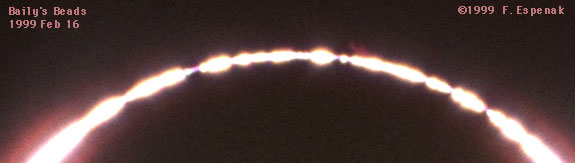
The following pictures were taken in February 1999, during the preceding eclipse of Saros 140, and you can see they match the simulations quite well although those were done at low resolution. Observers who wanted to have both a complete ring and a nice display of Baily’s beads had to be well inside the path by about 8 kilometers, the village of Greenough being indeed barely qualified: some of them decided to go a few kilometers to the south to be on the safer side. Similar pictures can again be taken during this annular eclipse. Beads and chromosphere can be seen on all the pictures that were taken without any solar filter. Note: not using any proper solar filter is not recommended unless you know exactly what you’s doing. If you are not experienced then please DO NOT ATTEMPT this and DO NOT LOOK THROUGH THE VIEWFINDER.
Picture taken without solar filter, about 13 seconds before second contact, by Fred Espenak from Greenough in Western Australia
Picture taken without solar filter, about 12 seconds after third contact, by Fred Espenak from Greenough in Western Australia
Picture taken without solar filter, about 9 seconds before second contact, by Fred Espenak from Greenough in Western Australia
Picture taken without solar filter, about 11 seconds after third contact, by Daniel Fischer from Greenough South in Western Australia
After carefully studying the lunar limb profile and looking at the map of the various locations near the edges of this annular eclipse path in Argentina, here are my main three recommendations:
- first if you choose to aim for the northern limit, then do make sure you are a good 6 kilometers (about 3.8 miles) inside the path to have both prolonged beads and a couple seconds of true annularity; if you go closer to the northern edge you’ll only get prolonged beads but the eclipse will never become truly annular.
- second if you target the southern limit, then do make sure you are a good 2 kilometers (about 1.3 miles) inside the path to get both prolonged beads and a couple seconds of true annularity.
- last make sure you take into account the elevation of your viewing location as it will slightly shift the limits to the north by about fifty meters for every hundred meters of elevation.
If you choose to be inside the grazing zone, that is closer to the edges of the eclipse path, then you will maximize the prolonged beads without any true annularity time. Be careful because many roads can be gravel ones, so take this parameter into account when computing travel times.
Weather-wise in Argentina I’d recommend staying west, next to the Andes, as this where you are likely to find the clearest sky for both the northern and southern limits, the best area being northwest of the small Rio Mayo town. Road number 40 will be your main access to the area and then gravel roads can bring you to your chosen location.
Map at the northern limit in Argentina
Unfiltered Baily’s beads simulation from the northwest of Pastos Blancos in Argentina
(created with Solar Eclipse Maestro)
Filtered Baily’s beads simulation from the northwest of Pastos Blancos in Argentina
(created with Solar Eclipse Maestro)
Map at the southern limit in Argentina
Unfiltered Baily’s beads simulation from the northwest of Rio Mayo in Argentina
(created with Solar Eclipse Maestro)
Filtered Baily’s beads simulation from the northwest of Rio Mayo in Argentina
(created with Solar Eclipse Maestro)
Centro Rio Mayo in Argentina
How to optimize your position using your smartphone
To know in real-time how good you’re doing in terms of position in relation to the the annularity path you can use this auto-tracking geolocation tool http://xjubier.free.fr/ase2017map?Map=ROADMAP
or a more complex map (all the URL on one single line with no spaces) http://xjubier.free.fr/xSE_GM?Ecl=+20170226&Acc=2&Umb=1&Lmt=1&Mag=1&Max=1&MapT=ROADMAP Remove the ?Map=ROADMAP at the end of the URL if you want to stay in the default SATELLITE mode. Of course the map mode can still be selected once the map is loaded. And the road traffic can be displayed as well.
The tool has been tested with success on a variety of devices from iOS to Android, Windows Phone and Blackberry. Nevertheless please report any problem you may encounter and don’t forget to provide a screenshot and a detailed description.
Then to activate the tool click on the lower icon on the left side, the one looking like a blueish shooting target . Once activated you should be prompted to accept being geolocated, so answer positively and the map should center on your current position and track your movements (it will work as well on a desktop computer connected via an Ethernet cable and even better via Wi-Fi). To deactivate the tool and stop the tracking click again on the button. Depending on your device you may have to authorize geolocation in the general settings as well. For example on iOS or OSX you should do so in the privacy settings. The detailed circumstances bubble is disabled while the auto-tracking geolocation is activated in order not to clutter the screen too much.