Transit map
A maximum transit diagram at the mouse-over location can also be displayed hovering the lower right corner of the transit map. The solar terminator can also be displayed in real time.
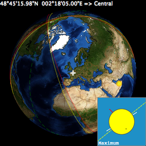

The transit map not only shows the transit visibility areas and the observer’s location, but displays also:
- the transit type at the mouse-over location
- the solar terminator animation
- the maximum transit diagram at the mouse-over location in the lower right corner
A contextual menu that can be invoked with a right click over the transit map will let you select various options:
- Show Transit Type Info - Display or hide the transit type info
- Sun-Planet Diagram at Maximum Transit - Display or hide the maximum transit diagram at the mouse-over location
- Cursor Tracking - Display or hide the geographic cursor coordinates
-
Mapping Settings
- Show Continents Contours - Display or hide the contours of the continents
- Show Continents and Countries - Display or hide the contours of the continents and the borders of the countries
- Show NASA Blue Marble Earth - Display or hide the NASA Blue Marble image of the Earth’s surface
- Show Greatest Transit Point - Display or hide the greatest transit point
- Show Map Scale - Display or hide the scale on the transit map
- Animated Solar Terminator - Display or hide the solar terminator animation
- Update Frequency - How often is the solar terminator animation updated from every 1 second to 10 minutes
- Zoom In (⌘+) - Zoom in by a factor of 2
- Zoom Out (⌘-) - Zoom out by a factor of 2
- Zoom Default (⌘=) - Reset zoom level to the default value
- Save Observer Orthographic PDF Map… - Lets you create a color high-resolution PDF file containing containing the transit diagram and an equirectangular projection map of the transit visibility areas from the observer’s location.
- Save General Orthographic PDF Map… - Lets you create a color high-resolution PDF file containing containing the transit diagram and an equirectangular projection map of the transit visibility areas.
To reduce the CPU activity and give as much time as possible to the process taking pictures while maximizing the autonomy of your laptop, you can turn off or lower the update frequency of the Sun-Planet diagram and transit map animations.
|