|
To get ready to observe the February 7, 2008 Antarctic annular solar eclipse from the Mount Vinson summit at 4,897 meters (16,067 ft), reaching in eleven days the Aconcagua’s summit at 6,962 meters (22,841 ft) is a good rehearsal. The Aconcagua peak is in a low pressures area, so its "physiological" elevation is believed to be near 8,000 meters and climbing it can be more challenging than many "7,000".
El Cerro Aconcagua, often referred to as the "Stone Sentinel" ("Centinela de Piedra"), with its 6,962 meters (22,841 feet) is the highest peak of the Americas and the highest peak in the world outside of Asia. This giant towers all the neighboring five thousand meters peaks.
Some of the various challenges to climb the summit are : fog, altitude, cold and winds, especially the "Viento Blanco"; those very cold winds can blow at 180 kph (110 mph) and the temperature can drop down to -45°C (-50°F). The normal route is a non-technical climb, the main and only difficulty lies 350 meters below the summit, the «Canaleta» is a rocky couloir with an elevation gain of more than 350 meters (1,200 feet) and nearly 50% slope. Depending on the season you can have some compact snow neve making the ascent harder in some places; crampons, ice axes and ropes are then mandatory.
Being well acclimatized to the altitude and an excellent physical condition are the keys to reach the summit. About forty deadly accidents have been reported on the normal route, most of the victims having perished of cold and exhaustion, after getting lost on the mountain.
To carry out all my expeditions and prepare the "Solar Eclipses" tours around the world, I am looking for sponsoring and resellers. Every year on average 5,400 people visit the Aconcagua Provincial Park and 3,650 try reaching the summit. Nowadays, the first thing a mountaineer does is check the Internet to find information on the recommended equipment and the various ways to prepare his expedition. Your sponsoring entitles you to get advertising space on my website with a link pointing to yours. Your company logo will also be displayed on my equipment and will appear in the various media used. Thank you all in advance for your support and help.
Click on thumbnails for a larger version
|
|
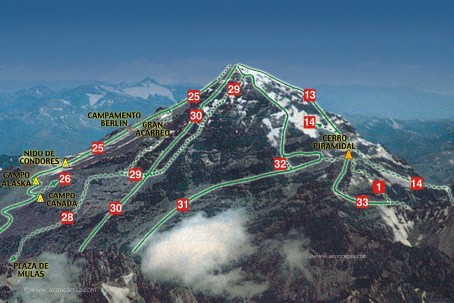
Access
From Santiago, take the international route to Mendoza up to Paso Los Libertadores. Past the argentine customs office there’s a place known as Puente del Inca (Inca’s Bridge, 2,700 m), equipped with a few food stands, an hotel and a military regiment. It is also here that the warehouses of the agencies which provide animal transportation are located. But before doing anything else you must drive to Mendoza to get in person your climbing permit. 10 minutes from Puente del Inca is the entrance to the Aconcagua National Park. It is here that the two-day hike up to to Base Camp "Plaza de Mulas" begins.
Approach
Normal route
From the park entrance it takes 3-4 hours to get to the first camp, known as Confluencia (Confluence, it is here that the stream which comes down the south face joins the Horcones river). The hike takes place along a road which later transforms into a light trail. In Confluencia there are many camping sites and there is even an "infirmary tent" and another "fast-food tent" where hamburgers and drinks may be purchased. The second day is a long 6-8 hour journey which takes to Base Camp "Plaza de Mulas" (mulas means mules). The first part of this hike follows the main trail until it enters the vast Horcones riverbed. For a long way, mostly without gaining any altitude, numerous brooks must be jumped over, sometimes even the river itself, which, even though it doesn’t carry much water, does have a very strong current. The last hours take place along a trail which winds over the slopes of Aconcagua’s west face until reaching Base Camp.
South Wall route
At Confluencia take on the right for a long 7-hour journey to Plaza Francia (4,100 m) Base Camp.
The Climb
Normal route (Northwest Face)
Plaza de Mulas is an extense plane at the foot of a beautiful mountain called "El Cuerno" (The Horn, 5,462 m). In summer the landscape is decorated with many multicolored tents, which contrast with the umber tones of the neighbouring mountains. It is a good place to acclimatize to the altitude (4,500 m) by allowing for adecuate nutrition and hydration. Some few hundred meters from this place is located the Refugio Plaza de Mulas, where it is possible to play table tennis and table soccer, besides from getting a good night’s sleep and nice meals.
Once acclimatized our goal will lead us to higher camps. There are many intermediate posible camp sites, but many of them lack the presence of water (or snow). It is recommended then to advance up to High Camp "Nido de Cóndores" (Condor’s Nest, 5,400 m), which is a spacious place and has snow, though it has the disadvantage of not offering adecuate shelter from the wind and, because of the uncountable expeditions that have already been here, isn’t quite a clean place... Between Base Camp and Nido de Cóndores it is 4-6 hrs along a large and loose scree slope. From this last camp it is possible to observe various sections of the route to the summit, the route being hidden at times by the rocky northeast arete. The route turns east and passes behind a rocky section for later returning to the center of the north face to cross the high part of the "Gran Acarreo" (Great Scree Slope). Above Nido de Cóndores exists another established camp site (Berlín, 5,900 m) where there is also a wooden shelter.
The summit bid may start at any of these high camps. The route goes along an easy and well trodden trail, except for a couple of hard snow fields that must be crossed. Finally, once the Gran Acarreo is crossed, the trail ascends up what is called "La Canaleta" (The Couloir), where the incline is somewhat strong and the size of rocks requires some scrambling. From the col between the east and west summits, only some minutes remain in order to reach the main summit. The summit bid takes aproximately 8-12 hrs, depending on the fitness and acclimatization of the climbers. It is recommended not to stay on the summit beyond 2 PM, since the descent takes a long while (4-5 hrs) and this allows to reach High Camp with daylight.
French 1954 route (South Wall)
The area of avalanches is at 20 to 30 minutes from Plaza Francia (4,100 m). There is a protected sector which is the right limit of the "Great French Spur". The climber reaches this place after transiting the Inferior Horcones Glacier at high speed. The route continues through a big dejection cone with ice and snow. The principal ice crevice should be crossed here from the most appropriate place (generally good and safe ice bridges). A band of grey rocks is immediately after this passage. It has low inclination, little difficulty, decomposition, and danger of falling rocks.
After climbing this grey rocks leaving below to the right the second principal ice crevice there are some black stratified rocks with favorable steps which allow a fast ascending. The alpinist should traverse to the right avoiding a spur and a big decomposed dihedral when climbing here. When reaching the left limit of the Middle Glacier’s Avalanche Canal, the climber should be very fast because of avalanche danger.
A fringe of grey-yellowish rocks appears next. They should be climbed slightly to the left, abandoning the former avalanche canal. When the terrain becomes steep and difficult for the easy progression, the route traverses to the right until the same avalanche canal transiting it for 50 meters. The objective here is to reach the limit between a fringe of yellow rocks and a fringe of black rocks. This limit is a natural pathway that leads to the ridge of the Great French Spur. Before the spur, there is an uncomfortable, unstable and steep stony slope, but easy to climb.
Once on the black rock spur’s ridge, a couple of tens of meters should be climbed until a little terrace. There is another terrace 30 meters uphill after a low difficulty sector. This place is apt for placing two little tents or bivouacs. It is very protected and at an appropriate altitude and distance for overcoming the Big Towers with enough comfort. The approximate altitude of this place is 4,500 to 4,600 m and it is at 3 to 5 hours from the Base Camp.
The real difficulty of the route begin here. The route climbs 50 meters on limestone and unstable rocks until a harder black rocky sector. This is an 8 meters climb of difficulty (IV) to (VI) according to the ice and snow on the rock. A passage of 120 meters (III) leads to a canal of ice and snow. The climbing should continue along this system of canals for about 200 to 300 meters with a variable slope of 40 to 45 degrees. Here is the base of the Big Towers. This rock formation is one of the principal obstacles of the wall. The route has plenty of rope’s rests and it is exceedingly pitonised in its totality.
The first length of rope in the Big Towers (III) and (IV) leads to a small rocky crest apt to give security. It is in the base of a big dihedral, immediately to the right of a frozen 50-meter cascade. This dihedral is very difficult, 30 meters (V) with a vertical exit (VI). There are nails along the whole passage. Then a small but comfortable recess is reached in the base of a narrow and deep chimney. The next length of rope is very uncomfortable (IV), with a vertical passage generally covered with ice (V). The exit of this chimney is very problematic. There is a narrow balcony near a canal after this wicked chimney.
This canal feeds the above named frozen cascade, which now is down to the left. The climber should descend about 5 meters to this canal. Once there, the route easily continues inside this canal for about 150 meters. The ridge of the spur is to the left. Here begins the Middle Glacier. Three rocks, as islands, allow to make the bivouacs away from the trajectory of avalanches. The altitude of this place is 5,200 m. The timing from the previous platform at 4,500 m is about 5 to 8 hours.
It takes one to two hours to cross the Middle Glacier if there is no ice penitents. The slope is about 40 to 50 degrees and finishes at 5,500 m in the fringe of the Limestone Rocks. Bivouacs can be done here. The Limestone Rocks are 200 meters high. Their quality is excellent but it is difficult to belay from them.
The condition of the Limestone Rocks as well as the Superior Glacier determine the total climbing time of the wall. This rocks accumulate a lot of snow, making the ascending difficult after a storm. In good conditions, the route is clear and the difficulty is (II) to (IV) with a short passage of (VI). The Limestone Rocks present a central snow layer, where the route passes through. A bivouac could be placed here but it is not quite safe and advisable.
After four lengths of rope (50 m rope) or five (40 m rope), the base of the seracs barrier of the Superior Glacier is reached. The altitude here is about 5,700 m. There are some bivouacking places, only for alpinists with steel nerves and when caught by the night or a storm.
The seracs barrier is 100 m high. Its climbing is hallucinating, more dangerous than difficult. The ice is perfect for modern climbing tools, and the belaying condition is excellent. The external edge of the Superior Glacier has plenty of places for bivouacking. The altitude is about 5,800 to 5,900 m. The timing from the base of the Middle Glacier (5,200 m) is about 6 to 9 hours. Slower teams should pass the night somewhere in between.
If the Superior Glacier has penitents or fresh snow, it becomes extenuating and requires almost a complete journey to be covered. The altitude gain is about 200 to 250 meters, with a lineal distance covered of 1,000 meters, because of the necessity to avoid the big transverse ice cracks. Avalanche danger is considerable during certain conditions, due to the slope (25 to 35 degrees) that allows an important snow accumulation.
After crossing this huge ice terrace, there is an edged spur to the right side of the Northern Summit’s vertical line. It is possible to place a bivouac near this spur, protected by some ice crevices. The approximate altitude of this place is 6,100 m. To get into the final spur abandoning the Superior Glacier, is a difficult and hard passage of the route. The most convenient way is to reach the big ice ramps in the left side of the spur.
The slope of these ramps is about 50 to 55 degrees. The cracks have vertical lips and there are falling rocks. The route goes to the right through this ice ramps of excellent quality, reaching the sharp ridge of the spur. There is a big formation of good rock. At its base there is a convenient place for bivouacking at 6,500 m. The timing from the Superior Glacier is 4 to 9 hours.
The climbing of this big rock formation requires two lengths of rope — difficulty (IV) to (V) and good belaying condition. Then, a sharp and exposed crest of mixed terrain (ice and rock) should be climbed — 20 to 150 m of (IV) to (V). This crest ends in some mixed, difficult and steep slopes, which are avoided traversing to the right and climbing on snow and ice — 40 to 50 degrees. Straight uphill, after a slope of 80 meters and 45 to 55 degrees, there is the superior limit of the South Wall. Here is the easy ridge of the Polish Glacier.
The timing from the base of the big rock formation is about 4 to 8 hours. From this point to the summit, 2 hours walking.
|
 Aconcagua expedition in Argentina


;)
;)
;)
;)
;)
;)
;)
;)
;)
;)
;)
;)
;)
;)
;)
;)
;)
;)
;)
;)
;)
;)